Historic Country Cycles
There are several cycle routes to choose from where you can enjoy the beautiful rural countryside and explore many of the historical sites Ballymoney Borough offers.
The Bush
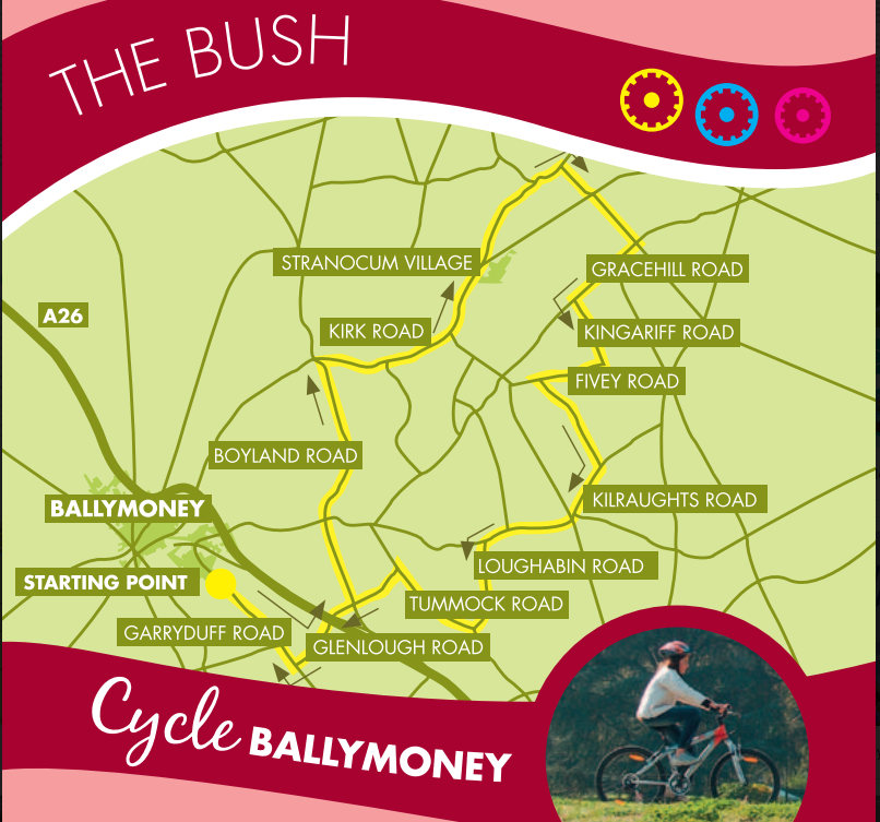
An 18-mile cycle that starts and finishes at the Joey Dunlop Centre takes in the village of Stranocum and the Dark Hedges, a group of three-hundred-year-old trees reputedly haunted by a spectral grey lady and form an arc over the road. This cycle also takes in Stranocum Hall, built in the 18th Century, and the Old Graveyard at Kilraughts, which dates back to the 17th Century.
Distance: 23 Miles
Starting Point: Joey Dunlop Leisure Centre
Directions:
Turn right onto Garryduff Road, then left onto Glenlough Road. Cross over the A26 – take extra care. At the next crossroads, turn left onto Boyland Road. Go straight over the next crossroads, continuing on Boyland Road. At the end of the road, turn right onto Kirk Road and continue through Stranocum Village and up the brae past the school. Turn right at Gracehill Golf Course onto Bregagh Road and up through the trees (known locally as the Dark Hedges). Go straight over the crossroads and descend to another crossroads. Turn right onto Gracehill Road, continue along, then turn left up Kingariff Road. At the top of the road, turn right onto Fivey Road. The minute you get past the houses, turn left onto Cregagh Road. At the end of the road, turn right onto Kilraughts Road. At Kilraughts Reformed Presbyterian Church, turn left onto Loughabin Road. At the crossroads, go straight over still on Loughabin Road, turn right into Tummock Road, then turn left onto Glenlough Road. Go straight across at the crossroads. Then straight over at the junctions with the A26 – take extra care. Continue to the end of Glenlough Road and turn right onto Garryduff Road and the Joey Dunlop Leisure Centre.
The Fisheries
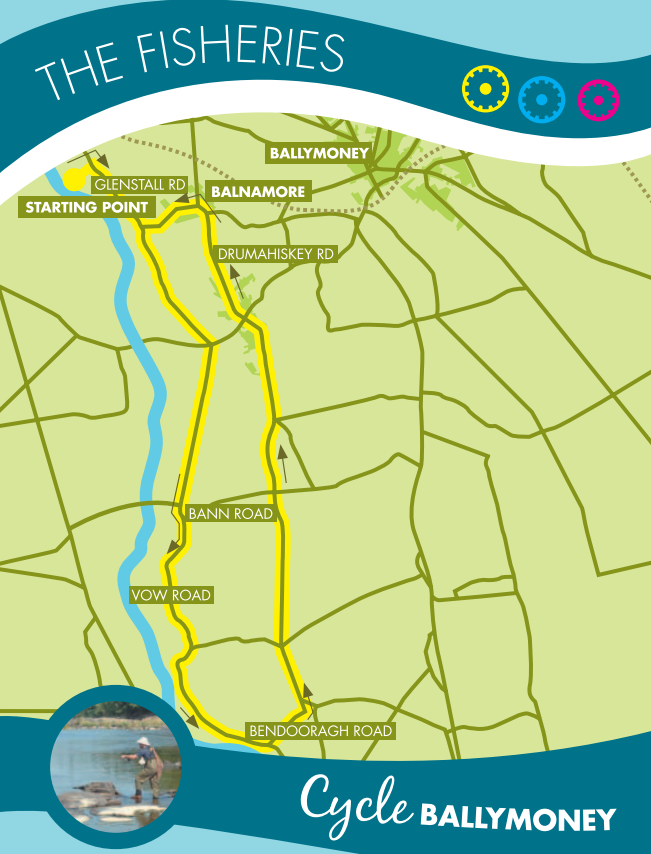
Starting at the Drumagheglis Marina, this 15-mile cycle takes you through the historic villages of Bendooragh and Balnamore. There are several historical points of interest to look out for along the way, including an earthen mound on Glenstall road, the Linen Mill at Balnamore, and Movanagher in 1615, the London mercers company managed the ford, fishery and surrounding farmland and built a fortified bawn. These sites are on private land and can only be accessed with the owner’s permission.
Distance: 15 Miles
Starting Point: Drumaheglis Marina
Directions:
Turn right onto Glenstall Road and continue to the end of the road. Turn left onto Bann Road and immediately right onto Vow Road.
After passing the Anglers Rest pub/restaurant, the Movanagher Fish The farm is a few hundred yards further on the right-hand side. Continue on Vow Road and then turn left onto Bendooragh Road. Continue along this road to Bendooragh Village. Go straight over the crossroads onto Drumahiskey Road, into Balnamore Village, and continue. Turn right into Glenstall Road and continue to the entrance of Drumaheglis Marina.
The Craigs
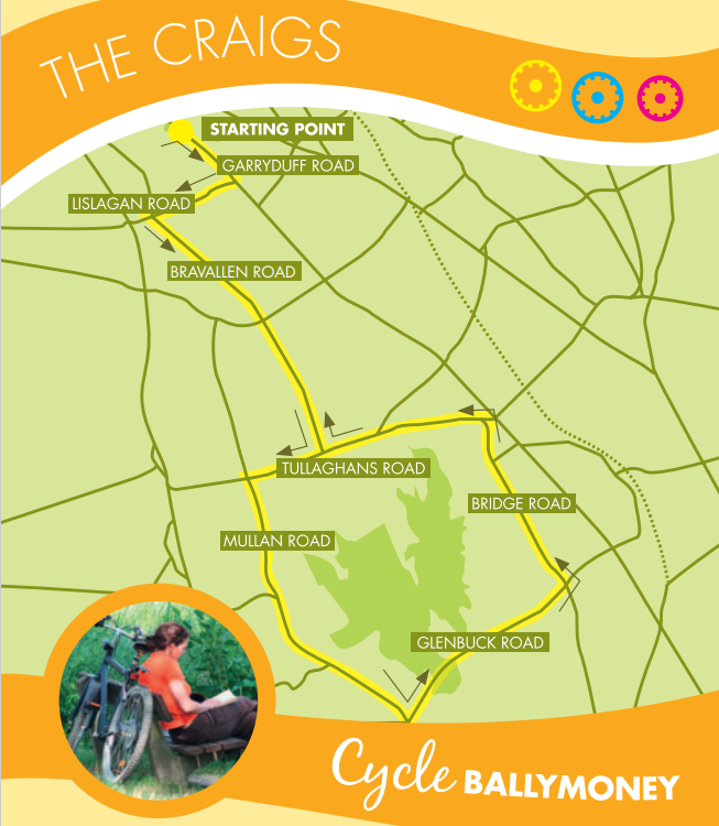
This 18-mile cycle starting and finishing at the Joey Dunlop Centre takes you on a scenic rural trip taking in many ancient sites on Long Mountain, such as the Broad Stone and Craigs Dolmen, which are Stone Age Graves. A well-preserved Stone Age Grave can also be visited at Dooeys Cairn near Dunloy. However, these sites are on private land and can only be accessed with the owner’s permission.
Distance: 21 Miles
Starting Point: Joey Dunlop Liesure Centre
Directions:
Turn right onto Garryduff Road, then right onto Lislagan Road, and turn left at the crossroads onto Bravallen Road. At the crossroads, go straight over. At the T-junction, turn right onto Tullaghans Road, then turn left onto Mullan Road. Pass Craigs Dolmen on the right and then Craigs Wood. Turn left onto Glenbuck Road and descend to the crossroads at Bridge Pub. Turn left onto Bridge Road and continue into Dunloy Village. Turn left onto Tullaghans Road and continue uphill until you turn right into Bravallen Road. Go straight over at the crossroads and continue descending to the next crossroads, where you turn right onto Lislagan Road. At the T-junction, turn left and continue to the Joey
Dunlop Leisure Centre.
The Mill
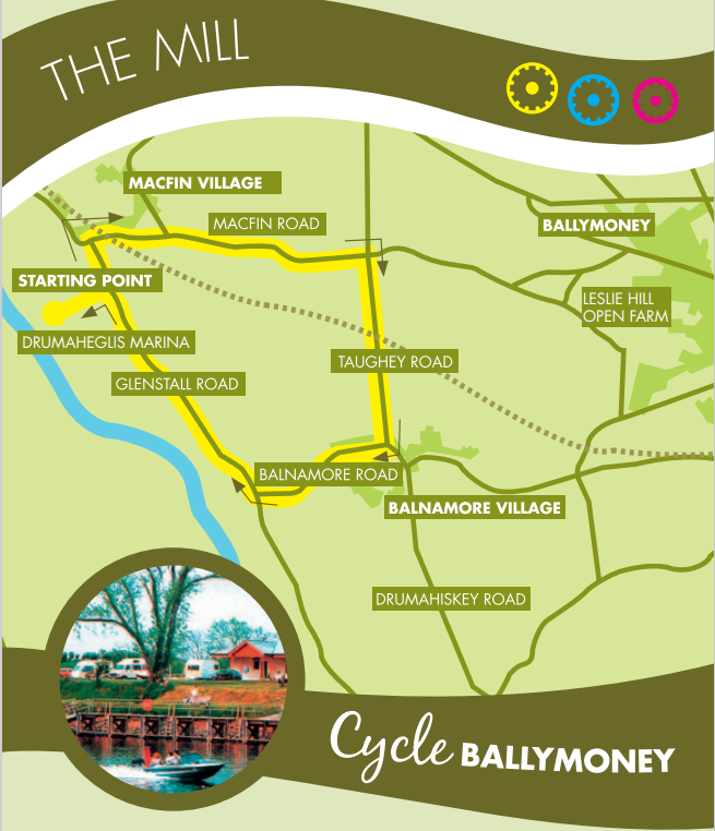
This short 5-mile cycle begins at the Drumaheglis Marina and takes in the villages of Macfin and Balnamore, and passes the entrance to Leslie Hill Farm. Historical points of interest to look out for along the way include the River Bann at Drumaheglis, where archaeologists have discovered evidence that Mesolithic people built settlements here.
Distance: 4.5 Miles
Starting Point: Drumaheglis Marina
Directions:
Turn left onto Glenstall Road at the T-junction, turn right over the railway and continue through MacFin Village. Take a right turn at the crossroads into Taughey Road (or continue straight ahead for 3/4 mile to visit Leslie Hill Open Farm, which is on the right-hand side). Following the Taughey Road, continue to the next T-junction making a right turn onto Balnamore Road. Continue through Balnamore Village to the next T-junction, looking out for the chimney at Balnamore Mill. Turn right into Glenstall Road and continue to the entrance of the marina.
The Castle
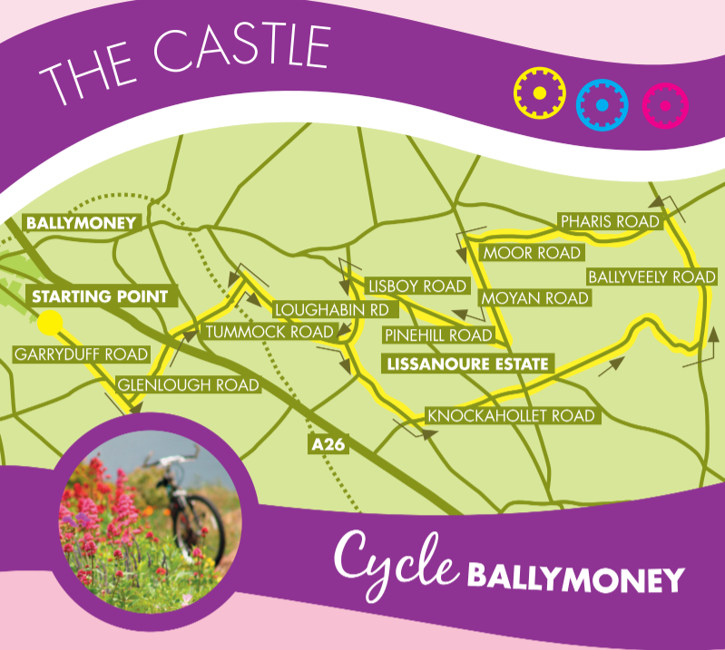
Starting and finishing at the Joey Dunlop Centre, this cycle will take you past several places of historical interest. On the right, after you pass Knockahollet School, are the remains of a Norman Motte & Bailey Forte. A Bronze Age Burial was also found on this site. Also, on the route, you will pass Lissauer Castle and the Hill at Kilraughts First Presbyterian Church, the gathering place for an army of 5000 United Irishmen in 1798.
For more information on these cycles, including a map and directions, see the Cycle Ballymoney Brochures.
Distance: 19.5 Miles
Starting Point: Joey Dunlop Leisure Centre
Directions:
Turn right onto Garryduff Road, then left onto Glenlough Road. Go straight over the A26 – be extra careful. Go straight to the next crossroads, continuing on the Glenlough Road and crossing the railway line. At the T-junction, turn right onto Tummock Road. At the end of the road, turn right onto Loughabin Road. At the crossroads, turn left onto Knockahollet Road. Continue to the crossroads and go straight over – take extra care. Continue to follow Knockahollet Road as it skirts Lissanoure Estate. Turn left onto Ballyveely Road. Continue to the crossroads where you turn left onto Pharis Road. At the crossroads, go straight over – take extra care. Turn left onto Moor Road. At the crossroads, go straight over, still on the Moor Road. Take care descending towards First Kilraughts Reformed Presbyterian Church. At the T-junction,turn left onto Moyan Road. Continue and turn right into Pinehill Road. At the T-junction, turn right onto Lisboy Road. At the crossroads, turn left onto Loughabin Road. Turn right onto Tummock Road. Turn left onto Glenlough Road, recrossing the railway line. Go straight over the crossroads and, with extreme care, go straight over the next crossroads with the A26, still on Glenlough Road. Turn right onto Garryduff Road and back to Joey Dunlop Centre.
Riverside Park
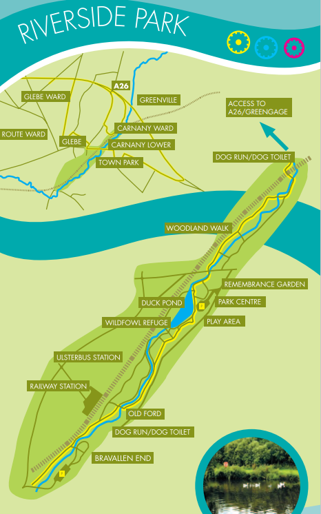
For a leisurely cycling experience, why not bring the family along to Ballymoney’s very own Riverside Park, situated right in the heart of the town,
Causeway Coast & Glens Council has provided several shared-use paths suitable for pedestrians and disabled users, and cyclists.
A one-kilometre, three-metre wide path has been established from Park Centre, adjacent to the main car park at Armour Avenue, to Bravallen Road, which is an excellent facility, particularly for younger children and beginners.
A second shared-use path has been established through the Rodeing Foot Wood and is accessible by crossing through the underpass below the Ballymena Road and taking the first accommodation bridge on the left. Follow this path to the tunnel under the railway, where a right turn leads to the A26 bypass, which swings left onto Kirk Road.
Following Kirk Road along to Greengage Lane will complete a circular loop. Turn left into Greengage and follow the lane downhill towards Greengage Cottages back to the railway tunnel on your right and re-entry into Rodeing Foot Wood. Most non-shared use paths in Riverside Park are also suitable for cycling but remember, pedestrians on foot and other path users should always be given the right of way.
So why not bring the whole family down to Riverside Park soon for a truly pleasant cycling experience and enjoy the other facilities on offer, including a first-class play area, duck pond and wildfowl sanctuary
Distance: 2 mles
Starting Point: Armour Ave
National Cycle Route 96
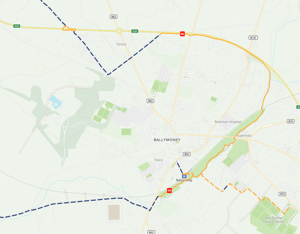
National Route 96 of the National Cycle Network runs through Coleraine and Ballymoney and connects with the Causeway Coast Cycle Route.
This route formerly ran from the top of Lough Neagh to Coleraine on the North Antrim coast. However, as much of it was on busy roads, it is now two separate sections of urban cycling in Ballymoney and the University town of Coleraine.
Ballymoney is one of the oldest towns in Ireland with many historic buildings in the town centre. The route runs along the Ballymoney River through Riverside Park, which is traffic-free.
Coleraine sits on the River Bann, and to the east of the town is Mountsandel Forest, which contains the Mount Sandel fort, an ancient site claimed as the oldest site of human settlement in Ireland. The route here runs along a stretch of the River Bann, parallel to Strand Road and is also traffic-free.
The Causeway Gateway route is mainly flat and traffic-free, so it is suitable for all abilities, whether you’re walking, wheeling or cycling.
Distance: 5 Miles
Starting Point: Ballymoney Train Station
Nearby routes
For more experienced cyclists, Route 96 connects with the Causeway Coast Cycle Route, part of NCN 93, but note that most of this is on-road.
Meadows & Moorlands cycle route
Cycling on the quiet country roads is an ideal way to explore Ballymoney and its surrounding villages.
The main cycle route links Ballymoney to the meadows and moorlands of North County Antrim. The area has a variety of raths, mottes and standing stones, testimony to an earlier age.
The route is best travelled in an anti-clockwise direction as this gives the best views of the villages and Antrim plateau. The route mainly uses country lanes, but care should be taken whilst crossing main roads and on the short sections of ‘B’ roads near Ballymoney. From Ballymoney town centre go east, crossing over the river and railway line, towards Dunaghy.
From here, the route turns south easterly and uses minor roads through rich farmland in the direction of Cloughmills. After a short climb, the route descends towards Loughguile, passing the picturesque Lisanoure Estate with its lake and old castle set among beautiful woodland.
After Loughguile, the route reaches its highest point at 185m, where superb views can be had of the Maine and Bush river valleys and distant forests. The return journey affords pleasant views of the River Bush and passes near the picturesque village of Stranocum. On the remainder of the route, keep a watchful eye for remnants of the former railway which ran between Ballycastle and Ballymoney.
Distance: 25 miles
Starting Point: Ballymoney Town Hall
The River Cycle Route
This route along the quiet roads on the East bank of the River Bann provides a great family cycle. From Ballymoney, travel west through Balnamore village towards Drumaheglis Marina and Caravan Park set on the banks of the River Bann. Head south towards Kilrea on the quiet road, which offers good river views. After the Angler’s Rest pub, you may like to leave the route to explore the old canal and weir at the fish farm. To return, take the first left south of the canal and travel north along the parallel inland road, looking across rich farmland with the Antrim Hills in the background. From Bendooragh you can either cycle the busy ‘B’ road to Ballymoney or travel straight ahead to return to Ballymoney via Balnamore.
Distance: 15 miles
Starting Point: Ballymoney Town Hall